Taiwan Strait
| Taiwan Strait | |||||||||||||||
|---|---|---|---|---|---|---|---|---|---|---|---|---|---|---|---|
 |
|||||||||||||||
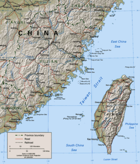
| A map showing the Taiwan Strait Area | |||||||||||||||
| Traditional Chinese | 臺灣海峽 or 台灣海峽 | ||||||||||||||
| Simplified Chinese | 台湾海峡 | ||||||||||||||
|
|||||||||||||||
The Taiwan Strait or Formosa Strait (formerly Black Ditch) is a 180-km-wide (111.85-mile-wide) strait between China and Taiwan. The strait is part of the South China Sea and connects to East China Sea to the northeast. The narrowest part is 131 km (81.4 mi.) wide.[1]
Contents |
Geography
Fujian province in China is to the west of the strait, while important islands like Jinmen, Xiamen, Hainan Island, and the Matsu Islands are nearby. To the east are the west coast of Taiwan and Penghu. The island fishermen use the strait as a fishing resource. The Minjiang and Jiulong Rivers empty into the strait.
History
The Strait has been the theatre for several military confrontations between the People's Republic of China (PRC) and the Republic of China since the last days of the Chinese Civil War in 1949 when the Kuomintang (KMT) forces led by Generalissimo Chiang Kai-shek retreated across the Strait and relocated its government on its final stronghold of Taiwan. A theoretical median line known as the cross-strait median (海峽中線) also exist on the water to prevent certain transportation from passing.[2]
As part of PR China's National Expressway Plan, a tunnel or possibly a bridge, was proposed in 2005 to link the cities of Fuzhou, Fujian, China with Taipei, Taiwan across the Taiwan Strait. If such an extreme construction would ever be built, it would by far exceed the length of any man-made tunnel in the world today. Engineers in Beijing state that a tunnel is technically feasible. Taiwan had refused to open direct links out of concern for the island's security and in fear that by doing so it would have to recognize Beijing's one-China policy.[3][4]
See also
- Cross-Strait relations
- Battle of Kuningtou
- First Taiwan Strait Crisis
- Second Taiwan Strait Crisis
- Third Taiwan Strait Crisis
- Political status of Taiwan
- Taiwan Strait Tunnel Project
- China Airlines flight 611
- Luzon Strait
Notes
- ↑ http://www.gio.gov.tw/taiwan-website/5-gp/culture/calligraphy/index.html
- ↑ Chinareviewnews.com. "Chinareviewnews.com." 大公報文章:“海峽中線”應該廢除. Retrieved on 15 July 2009.
- ↑ Wu Zhong (January 14, 2005). "Mainland to triple highway network". The Standard. http://www.thestandard.com.hk/stdn/std/Front_Page/GA14Aa01.html. Retrieved 13 December 2007.
- ↑ Plans unveiled in China for Taiwan tunnel | World news | The Guardian
Further reading
- Bush, R. & O'Hanlon, M. (2007). A War Like No Other: The Truth About China's Challenge to America. Wiley. ISBN 0471986771
- Bush, R. (2006). Untying the Knot: Making Peace in the Taiwan Strait. Brookings Institution Press. ISBN 0815712901
- Carpenter, T. (2006). America's Coming War with China: A Collision Course over Taiwan. Palgrave Macmillan. ISBN 1403968411
- Cole, B. (2006). Taiwan's Security: History and Prospects. Routledge. ISBN 0415365813
- Copper, J. (2006). Playing with Fire: The Looming War with China over Taiwan. Praeger Security International General Interest. ISBN 0275988880
- Federation of American Scientists et al. (2006). Chinese Nuclear Forces and U.S. Nuclear War Planning
- Gill, B. (2007). Rising Star: China's New Security Diplomacy. Brookings Institution Press. ISBN 0815731469
- Shirk, S. (2007). China: Fragile Superpower: How China's Internal Politics Could Derail Its Peaceful Rise. Oxford University Press. ISBN 0195306090
- Tsang, S. (2006). If China Attacks Taiwan: Military Strategy, Politics and Economics. Routledge. ISBN 0415407850
- Tucker, N.B. (2005). Dangerous Strait: the U.S.-Taiwan-China Crisis. Columbia University Press. ISBN 0231135645
- Wallace Thies, and Patrick Bratton, “When Governments Collide in the Taiwan Strait,” Journal of Strategic Studies, 27, no. 4 (December 2004), 556-84.